


Kayaking the Bass Strait - A How To Guide.
- Mar 16
- 10 min read
Updated: Mar 22

Kayaking the Bass Strait sits high on any Australian adventurers bucket list. The 330 kilometre stretch of sea between mainland Australia and our home of Tasmania is known for its treacherous weather, ripping currents and volatile sea states. But what many don't realise is that it is dotted with some of the most stunning islands in the world. Each year around 30 kayakers attempt to skip across these islands on the Eastern side of the Strait, and in 2026, Elise and I decided to have a go ourselves.
*Disclaimer - We do this kind of silly stuff for a living.
Quick Trip Overview
Direction: Victoria to Tasmania
Start date: February 9th at 9:30am
End date: February 24th at 4:30pm
Start point: Port Albert boat ramp. We started here as we had a friend there and could use their home as a staging ground for launch. Most paddlers leave from Tidal River.
End point: Little Musselroe Bay campsite where we had our car already dropped and waiting.

Islands and distances:
Day 1: Port Albert to Refuge Cove - 54km
Day 2: Refuge Cove to Hogan Island - 54km
Day 3, 4, 5: Rest on Hogan
Day 6: Hogan Island - Erith Island - 42km
Day 7: Erith Island to Deal Island (Garden Cove) 4km
Day 8: Rest at Garden Cove
Day 9: Garden Cove to Winter Cove (Deal Island) - 7km
Day 10 and 11: Rest on Deal
Day 12: Winter Cove to Roydon Island - 64km
Day 13: Roydon Island to Whitemark for resupply - 33km then onto Trousers point - 13km
Day 14 and 15: Rest and hike Strzelecki Peak
Day 16: Trousers point to Little Musselroe Bay - 65km
When to start and direction of travel
In general, the most stable and reliable weather is February and March as the prevailing winds will be in your favour if travelling from North to South. In saying this, we met a team of two men who were going South to North and it wasn’t an issue – they were just waiting for low wind days like us.
We had beautiful clear sky days (windy, but clear) and were lucky with only one day of very minimal rain.
When it comes to the direction of travel you choose I would suggest ENDING in the state closest to your home. By this I mean you will have your Spirit of Tasmania ferry crossing at the beginning of your trip, and not have a ferry deadline looming over you. The ferry at this time of year is very hard (and expensive) to book or change last minute.
How long will you need
We took 16 days to complete the crossing. This included around 9 days of waiting for good weather on the islands. Conservatively, and so as not to be worrying about deadlines, I would leave three whole weeks to complete the crossing (this excludes travel to and from the start). The more time you have the better.
While you could punch out this crossing quite quickly it would be an absolute waste to not enjoy the islands – they are magnificent. We had three days on Hogan, five days on Deal and three on Flinders and could’ve stayed much longer. This is a once in a lifetime adventure – don’t rush it.
Your vessel
It’s fair to assume most people that are thinking of attempting this crossing already kayak regularly (or have done so) and/or own a kayak of their own they would use. Elise and I fit neither of these categories. We borrowed a Mirage 730 (now a 732) tandem kayak without a sail. It had a AA battery powered bilge pump (crucial!) and was very well looked after by its owner.
Prior to the trip, we did two practice days out around Port Arthur in it and felt pretty confident in calm conditions.
The pros of a tandem
We were surprised with how much we enjoyed being in a tandem. It meant we could chat easily, make plans and decisions without having to ‘regroup’ and could keep the kayak moving the whole time. Every hour one rested while one kept paddling. It was easy enough to manoeuvre up the shoreline for overnight with the two of us after we unloaded it a bit.
The cons of a tandem
Less storage space means you have to be a little more strategic about what you pack, but we found it easy to fit everything in. Because most of the space is taken up with food it frees up quickly as you eat it.
Navigation
Navigating the bigger crossings - Wilsons Prom to Hogan Island, Hogan to Deal and Deal to Flinders - are your biggest concerns. We used the app Navionics to check our bearing on departure and then regularly throughout our large crossings, with Elise monitoring the deck mounted compass in front of her. This app is amazing, as it shows course over ground and considers current drift as well as heading and shows you where you will end up if you continue on the course you are on. We were lucky and had clear days so could see our island targets not long into the crossing each time. Then of course there is the a map and compass as a back up.
Weather and setting your wind thresholds
This crossing is all about the weather. Watching it, waiting for it, dealing with it as it changes mid crossing. We used the Windy app and crossed checked it with PredictWind. These were pretty accurate the whole crossing. We also had friends message us through our Garmin devices relaying the weather when we didn’t have service.
Because of our lack of kayaking experience (let alone ocean kayaking) we didn’t know what we were and weren’t comfortable paddling in when it came to wind speed. We quickly learned on the last few hours of day one that even a light headwind of 20km/h was not fun. Then, day two blew up even worse in the last few hours of the day. This was our lesson to decide our max wind threshold and stick to it.
We chose 15 knots (28km/h) as a safe upper limit of wind for us. Anything above and we would stay put. This included gusts. Some other great advice we got was never try to race a Westerly. If we saw a Westerly front coming in during the afternoon we waited, as they can often charge through hours earlier than predicted.
If Windy read 20km/h with gusts of 40km/h consistently all day we wouldn’t paddle.
Rain was fine. But wind could turn a long day into a complete and utter sufferfest – but more than that, it would make it completely unsafe and would be ridiculous to be out there risking it.
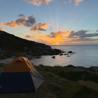
Be prepared to wait for good weather. Our longest wait was on Erith/Deal Island for five days. We were never bored. You can do little hops to different campsites on the Islands and there are trails all over.
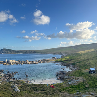
The Camps/Islands - Water sources, facilities and cell service
Refuge Cove: We originally were aiming for Sealers Cove but decided to add the extra one kilometre. Refuge Cove was a stunning hour glass bay with a hikers camp just up the creek line and a boaters camp on the north foreshore. Both areas have camp spots and drop toilets. There is a small water spout up the creek line near the hikers camp that feeds down the freshwater but it was very slow when we arrived in the evening and was completely dry by the morning. Carry enough water to get you through this camp and onto Hogan.
The march flies and mosquitoes were NUTS here - be prepared.
No Telstra cell service.


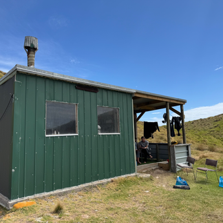
Hogan Island: The protected northern bay is heaving with fish and a stunning spot to hang out for a few days. It’s relatively rock free to beach the kayak and easy to pull them out of the water up above the high tide. There is an awesome fishing hut to relax in if the weather isn’t on your side with fresh running water into a trough a 50 metre walk from the hut. We drank it without treating but it’s probably best to treat it.
Although there is no track, you can reach the lighthouse through awkward deep grassy terrain. Rock hoping around the shoreline is more fun.
Telstra cell service in the saddle just behind the hut.
Erith Island: The Erith and Deal Island couplet is an amazing place to hang out for a few days. We camped at Erith for one night with the Erith mob before moving over to Deal. The mob were lovely and let us fill up as much water as we needed from their tanks on the East side of the beach. The camping spot is behind the sign, just off the beach in the middle of the bay. There seems to be some great hiking tracks around but we didn’t spend enough time here to explore.
The Island is marine protected so there is no fishing.
In the places we camped there was no cell service, however we didn’t go looking for it so there might be some around.
Deal Island: Deal has a caretakers cottage where you can refill from the tanks. The caretakers rotate every three months, so make sure you seek them out and ask for a refill and potentially use of their internet for weather checks. Close by is a museum with the islands history and is worth a look. This main bay isn't really for camping so it's best to head around to either Garden Cove or Winter Cove.


Garden Cove doesn't have great spots to camp but is closer (2km walk on great track) to the cottage. We camped on the trail as it was the clearest from scrub. There is a small brackish fresh water creek at the trailhead that would be fine for refills in an emergency, but we just walked to the cottage.
There is no telstra service here. On the trail back towards the cottage there is a little spot with a blue chair in the bush that has 5G service. If you are friendly the caretakers may give you access to their internet for weather checks.


Winter Cove has a great camp spot at the southern end of the bay. In the middle is a brackish fresh water creek that you could filter water from if you were desperate. It is a 4 km walk to the cottage, on maintained trails. The caretakers leave two 20 litre water jerries just at the top of the hill from the bay for kayakers, otherwise you will have to walk to the cottage. This is the best spot to launch from to tackle the big crossing to Flinders Island.
We had intermittent Telstra service right at the top of the hill, but mostly had to walk to the cottage to check the weather forecast.


Roydon Island: Many paddlers cross from Deal to Killiecrankie as it is the most direct route to Flinders Island. We had met a few guys that said Roydon Island was magical so decided to head straight there. It was a 9.5 hour day on the water in perfect conditions. Coming around the headland into Roydon and just off the East of the island, got a little wild from currents and tides so don't relax.
Another thing to be conscious of is the outgoing tide as you come towards Flinders. It can force you back off shore and turn an already long day into an absolute saga.
Roydon has a fishing hut and is a perfect spot to hang out for a few days. There are two small water tanks for refills and great telstra service. Enjoy the soothing sounds of penguins yelling at you through the night. There's a spot for cooking on a fire if you happen to have fishing gear.


Flinders Island: There is no shortage of camping spots on Flinders. We ducked into Whitemark to resupply at the IGA and have a feed at the Corner Cafe before continuing to Trousers point.
As you enter Trousers Point the best spot to stop is the little beach with stairs on your left before hitting the main beach. The stairs take you straight to the campsites. This area has recently been renovated and has great BBQ facilities with shelter, a water tank, toliets and more than enough campsites with picnic tables. From here it is about 3km walk (or hitch if you get lucky to meet some kind locals like we did) to the start of the Strzelecki Peak Trail which I highly recommend. We had great Telstra service all over Flinders.


There are many options after Flinders Island for stops including Key Island bay on Cape Barren, Preservation Island and Rebecca Bay on Clarke Island. However, I can't speak to the water, camping or cell service situation for these locations. I do recommend staying at at least one of these spots instead of doing what we did and pushing all the way from Trousers Point to Tasmania.
Safety
Below is what we carried in regards to safety equipment. Each state has slightly different requirements but we based it off Tasmania Paddle Craft requirements. Your safety comes down to making good decisions. Know your limits, plan for worse case scenarios, and don't ever think you can out run Mother Nature.
Epirb/PLB
Tracker - Garmin or similar
Lifejacket
Flares
Glow sticks
Marine radio (VHF)
Throw rope
Bilge (auto and handheld for backup)
Compass
First Aid kit
Cat 4 sunglasses
Fitness
As mentioned Elise and I had very little paddling experience before going into the trip. In saying that, we train year round to be able to do most things semi efficiently and are very fit. I have also had an extensive amount of time in ocean rowing boats so understand the ocean well.
A few days into the trip we learnt how to use our legs, that was a nice lesson that would've saved our shoulders from taking the brunt of it.
If you pick good weather days, rest properly and are reasonably fit and injury free you shouldn't have a problem completing the crossing. We started the trip as a team of five. On Deal Island we ended up splitting the team as they were stronger paddlers than we were and were comfortable in higher winds and worse conditions.
The thing that hurt us the most was sitting down for so long without the ability to stretch our hips.
Extra little tips
Just pee in your kayak, especially for the women. It's so much easier than worrying about a pee bottle and you can bilge it out later.
Protect your food from the rats. We had a little visitor on Winter Cove that chewed through my tent to get into our snacks.
It was handy having a CamelBak in our lifejacket.
If you are a keen spearfisherman/women then I recommend trying to fit your gear into your packing list. We met two guys who had done this and they were feasting on fish, crays and abalone every night. The marine habitat out there is incredible. At the very least bring a handline. At the very, very least bring goggles and a snorkle to enjoy the scenery.
Do not have a deadline, stick to your upper wind limits, and make good decisions.
A detailed chapter about this expedition will appear in my next book, in the meantime reach out below with any questions you might have about gear, navigation or anything I might have missed. Now go and get out there.
One life, one chance.
Luke
Comments